I’m off again! This time I’m on my way to the south west of England to attempt the difficult South West Coast Path. I'm off on Wednesday 11th May, almost exactly a year after my Coast-to-coast walk.
In case you followed this blog and would like to follow me on the South West Coast Path, I thought I would let you know by posting here.
The link below will take you to the new blog, though there won't be a post until Wednesday evening! If you would like to receive daily email notifications of the latest posts, please enter your email address at the top right, and follow the instructions. Please be sure to click on the link you receive in an email from Feedburner/Google. It is perfectly safe!
It will be great to have you along….
South West Coast Path
Monday 9 May 2016
Monday 24 August 2015
Postscript: Striding Edge and Helvellyn
Weather: Cloudy and still
|
||
Distance covered today: 14.6km (8.8mi)
|
||
|
||
Says Wainwright; “Early writers regarded Striding Edge as a place of terror, contemporary writers, following a modern fashion, are inclined to dismiss it of no account. In fact, Striding Edge is the finest ridge in Lakeland. For walkers, its traverse is always an exhilarating adventure in fair weather or foul, and it can be made easy or difficult according to choice. The danger of accident is present only when a high wind is blowing or when the rocks are iced; in a mist or on a calm day, the Edge is a really fascinating place.” (Thanks to Paul for that quote).
In time, Wainwright became more critical of the Helvellyn route. In his “Coast-to Coast Walk”, he suggests Helvellyn “has two big attractions apart from its lovely name and literary associations – a very extensive view and the exciting traverse of Striding Edge – but it is a tourists’ mountain, very much so: in fact the most often climbed mountain in the country. The paths, worn as wide as roads, are stony and dusty and noisy with pilgrims.”
Those of you who have toiled through my blog will already have experienced my angst about missing Helvellyn and Striding Edge, and indeed my encounter with the red devil. It had to be done! A plan was hatched.
Initially, my idea was that I would climb it with my daughter, Anna and her husband, but as things developed, his family also came on board as well as Edmund, an old friend of ours and an experienced fell walker. The weather looked likely to be a problem, but taking our lead from Wainwright, we decided that we would ascend Helvellyn in “fair weather or foul”, provided only that it wasn’t windy or icy (the latter unlikely in August!). At the last minute, Anna dropped out with a recurrence of an old rugby injury to her knee. (Yes, my petite and lovely little Anna used to play rugby…..)
We set out on the standard circular route from Glenridding to the summit of Helvellyn via Striding Edge and then back down via Swirral Edge and Glenridding Common. In fact I found the paths less worn than Wainwright had suggested and there were fewer people walking than expected, though we were always in sight of other walkers. Wainwright was of course very pernickety about paths and people, so perhaps I shouldn’t have been that surprised. I was intrigued to discover that with an absolute height of 950m and a relative height of 712m Helvellyn is the second highest “Marilyn” in England, though it is of course a minnow compared to the Scottish whales. It transpires that a Marilyn is a mountain or hill in the United Kingdom, Republic of Ireland or Isle of Man with a prominence or relative height of at least 150 metres (492 ft), regardless of absolute height or other merit. The name was coined as a punning contrast to the designation Munro, used of a Scottish mountain with a height of more than 3,000 feet (914.4 m), which is homophonous with (Marilyn) Monroe. See the Wikipedia article here.
Approaching Helvellyn from the Grasmere side, Wainwright commented that “the gradient eases after an eternity of toil” and that was certainly what it felt like to me! In my case though, the excitement of suddenly seeing Striding Edge itself for the first time after all these years completely transfixed me. I found the path along the Edge less vertiginous than I had expected, though I had some difficulty negotiating the scramble at the far end, such that I kept our party waiting while I fastidiously clawed my way down, along and up the rocky ledges. They were all very understanding!
The weather forecast had predicted heavy rain from midday onwards, but the unpredictability of the weather in Lakeland for once worked in our favour, as if apologising for previously sabotaging me on Kidsty Pike! The rain held off until we returned to base from outer space, at which point it literally bucketed down, complete with lightning and thunder. We couldn’t have been luckier.
As we walked over the remarkably amicable breast of Helvellyn to the cairn at the summit, having finally transited the Edge, the sun appeared and bathed the most stunning views I have seen in England in breathtaking contrasts in all directions. Simply stunning!
I now understand why people do this walk more than once…..

The ascent out of Glenridding

Looking back at Ullswater
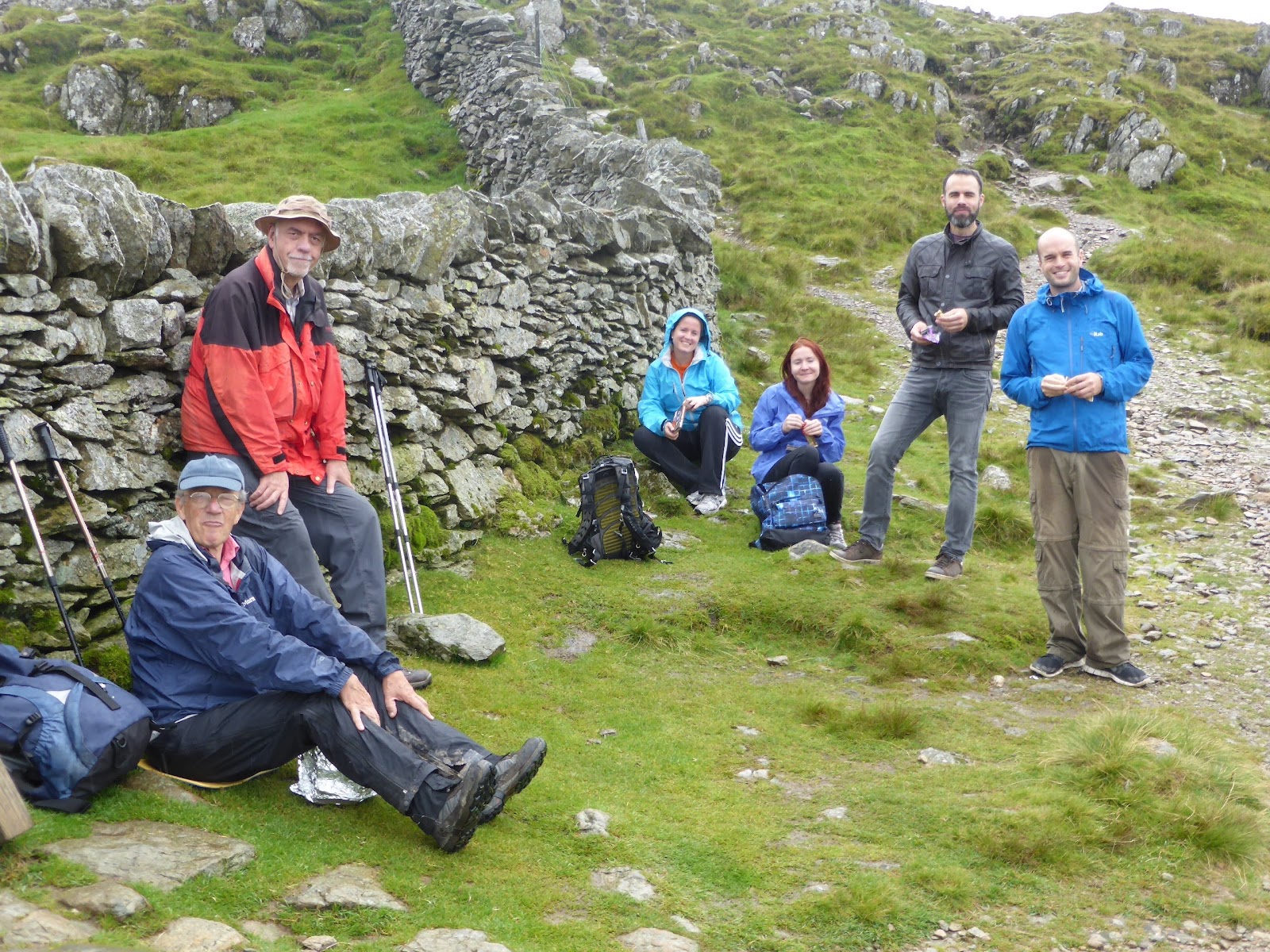
Lunch at "Hole in the Wall". A moment for serious contemplation!

I can't resist these atmospheric walls in the middle of nowhere
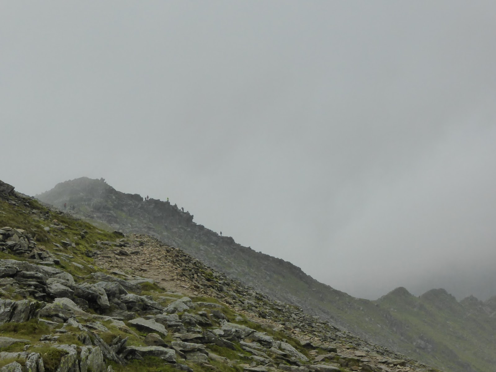
Striding Edge suddenly appears! Those tiny, pointy things are people!

The Edge gets closer!

Looking down at the exquisite Red Tarn

Even closer to the Edge!

Brotherly affection
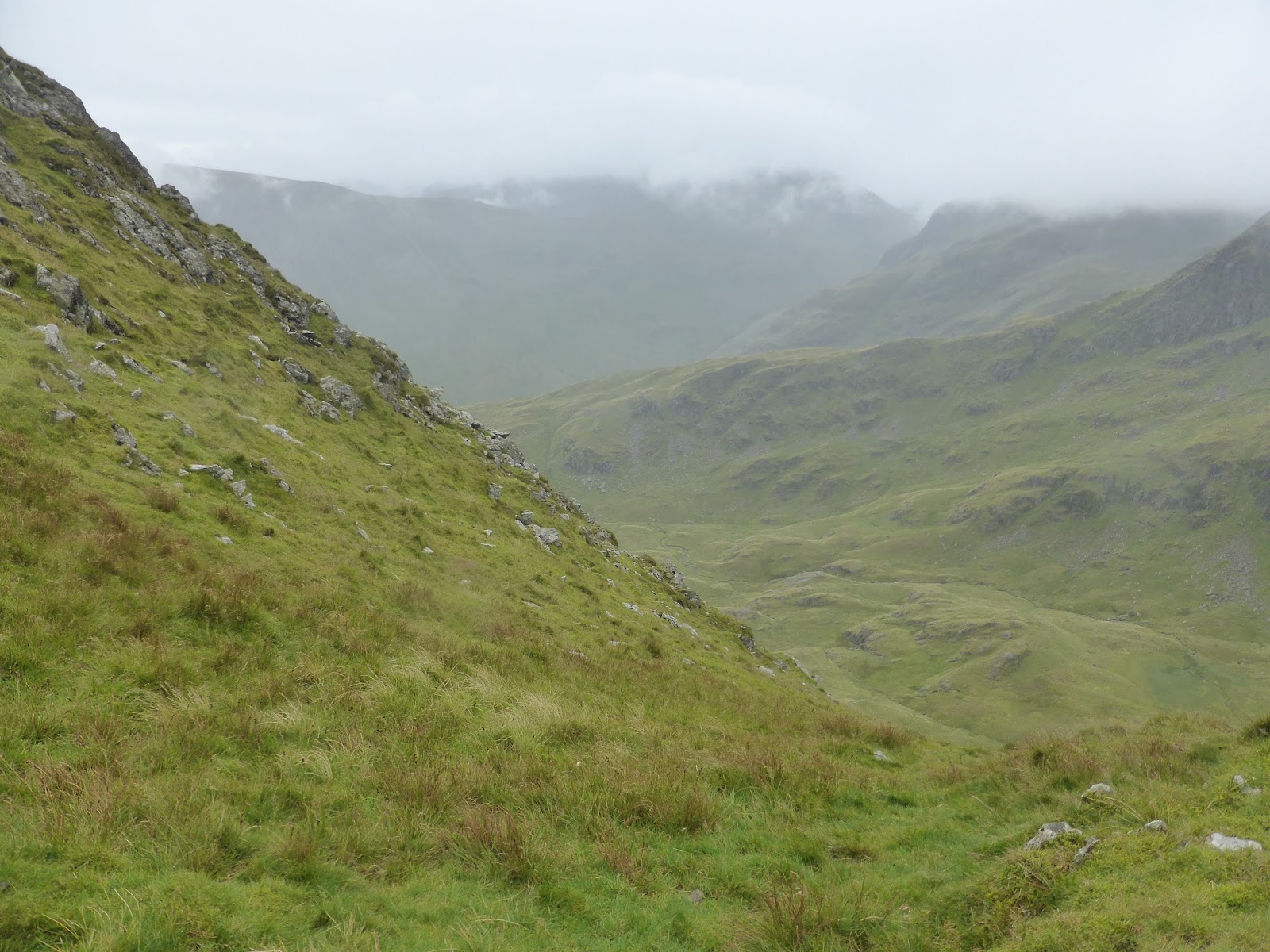
The valley to the South

Iain ascends the Edge!

Experience.....

We make it to the other end of the Edge

The view from the top of Helvellyn

Nonchalantly approaching the summit

Team pic!

Descending to Glenridding. A thigh-burning 900m descent

The hands say it all!

Elevation profile: Striding Edge is clearly evident, including the perilous little descent just before we faced the scramble towards the top of Helvellyn
Thursday 21 May 2015
Day 15: Grosmont to Robin Hood's Bay
| Weather: Mostly sunny with light winds |
| Distance covered today: 25.6km (15.9mi) |
| Last night's B&B: The Gallery B&B |
| % Complete: Cum distance: 100%: 317.9km (197.5mi) |
| Total Ascent/Total Descent: 704m/ 736m |
| GPS satellite track of today's route: Day 15 (click!) |
It’s just over a fortnight since I started the Coast-to-coast and it’s hard to believe it’s over. In such a relatively short distance, I have experienced so many different geographies, states of mind, people and experiences that I feel really quite moved. I say a relatively short distance, because in fact the C2C isn’t really a very long walk. After all, on my LEJOG journey, I was only just north of Exeter after the same distance, but the two experiences can’t be compared. From the glory of Lakeland and the adventure on Kidsty Peak to my joyous return to the Pennines and my acquaintance with the Cleveland Hills and the North Yorkshire Moors, this has been everything I had hoped for, and more. Normally, by the end of one of these walks, I’m quite happy to return home and get on with things, but I have been so inspired by this experience that I spent some time today trying to work out what to do for an encore next year!
So what do I feel about the Coast-to-coast? In many ways it is by far the most varied of the walks I have done (LEJOG excepted), but also the most demanding. I have been at times quite amazed at how under-prepared some participants have been, with the result that sales of Compeed (blister plasters) have rocketed. Yesterday I was amused to hear one fellow from Austen, Texas, on a National Geographic guided walk, wearing sandals because he has so many blisters that he just can’t wear boots anymore, saying that no-one told him there were so many hills in England. He said that he had thought that England was all flat green fields!
Initially I was a little put off by the sheer weight of numbers and it remains true that if you want a quiet walk in the country alone with your companion or your thoughts, then the C2C is not for you. However, as time has passed and as passing acquaintances have steadily deepened, as people have visibly changed, sometimes with increased confidence and sometimes the opposite, it has all become more of an experience than I had anticipated. As a boy, I was constantly subjected to immersive experiences, designed “to make a man of you”, mostly disagreeable, but probably effective. During most of my working years, other than the odd lunacy branded as corporate team-building, I managed to avoid that sort of thing, so it is especially strange to be hurled back into the midst of it, but among an older and much more mature set of people. All I can say for certain, is that as the muscles have tightened and the callouses hardened, so it feels that the pain was all worth it and I feel very much healthier than when I set out. I can’t think of a better retreat in the good old Jesuit sense of the word!
Of course, I have been lucky in all sorts of ways. Though the Met Office records that the first half of May has been quite wet in the UK (as a whole the UK has had more rain in the first 17 days than the average for the month of May), the rain mostly held off, and with the exception of Kidsty Pike, the weather came mostly from astern driven by westerly winds, and for a walker that really isn’t a problem at all.
My equipment all worked perfectly and my little Garmin satnav, prepopulated with daily routes, carefully plotted by myself using the Ordnance Survey online mapping service and Martin Wainwright’s C2C guidebook, meant that despite the absence of waymarks on the C2C, I didn’t ever get lost (though of course I was helped by David and Gay on Kidsty Pike where I just couldn’t see a thing). The magnetic compass and the barometric pressure altimeter built into my satnav have proved useful innovations. I have learned from the experience of previous walks and I now understand that the use of decent clothing and equipment makes the whole experience both safer and more enjoyable.
Not everything was perfect. In particular, I was disappointed with the service and facilities in a number of the B&Bs along the way. As a general rule, I have found that the more popular the route the less accommodating the B&Bs, because they have a captive clientele, which I suppose is obvious. By far the best experiences were those that were off the beaten track, where I was collected and returned to a point on the route by the proprietor. These people have to work harder for their living and they also look after customers who aren’t walkers and who expect better service, and they do receive it. By and large, though, the standard of facilities was quite adequate: even the power showers are mightily improved from just a few years ago. Availability of wifi in bedrooms was patchy at best, but then not everyone is a geek like me who needs permanently to be connected to the net! Even in this area, though, things are improving, with the use of repeaters and increased understanding of the advantages to the business of having good access. Keld Lodge was by far the most outstanding experience of the trip, despite being right in the epicentre of the route. I would recommend anyone to go there even if you aren’t a walker. You will enjoy it! The Gallery in Grosmont was a distant second.
Finally, I have heard privately that some feel that I have been a bit of a grumpy old man in these posts. I was rather disappointed to hear that, because it honestly isn’t the way I feel about it, and it must be that in expressing my thoughts too quickly, I have perhaps not reflected sufficiently on the result. My excuse can only be that the pressures of the walks, including getting all the verbiage, photos, maps and data out on time, when sleep calls and another stern test awaits tomorrow, presents something of a challenge. All I can say is that I heartily recommend the C2C to anyone who might read these notes. It is an experience you will never regret!
And so to Robin Hood’s Bay. My guide-book advised me to throw my pebble from St Bees into the North Sea and I’ve done that, including wetting my boots in its waters. It says that I have been “playing (my) part in a steady geological transfer that may one day baffle scientists”. The book goes on to say, “Then celebrate and don’t feel let down by the absence of cheering crowds. Robin Hood’s Bay is a mecca for trippers who are unlikely to know of your amazing feat, and wouldn’t care if they did. There may be a few, instantly recognisable, fellow ancient mariners, slumped about who will exchange yarns. And anyway, you know what you have achieved, and that is all that matters in the end.” Amen to that, and I’m off to Wainwright’s bar in the Bay Hotel to see if I can find some of my ancient mariners!!
To end, I recall the late arrival of my suitcase in Kirkby Stephen. I was talking to the attractive assistant behind the bar, telling her that I was off to take a shower, so if the suitcase did arrive, please would she not bring it into the room. The gruff, Yorkshire twang of the proprietor erupted from a dark corner, “Not to worry, mate. If she does go in, we’ll add it to yer bill!”

My beautifully appointed and decorated B&B in Grosmont last night

Elegant Victorian houses on the steep climb out of Grosmont

Everywhere there are the yellow bicycles commemorating the sensational start to last year's Tour de France

At last a lapwing! It took ages to get him to stand still!

Eric and Jane saw me walking along the road as they passed in a car and slithered to a halt to say good-bye! Really touching!

The beautiful little village of Little Beck

The flowers are improving by the day! A sea of Stichwort!

Chubb's eccentric cave

Falling Foss

Wooden paths over the bogs on the moors of Graystone Hills

My much missed pom-poms. They appeared all over the Pennine bogs years ago but perhaps it is too early in the season this year

How amazing a colour combination! The grey of the moors with the yellow of the gorse

The first explicit sign to Robin Hood's Bay. Relief and regret...

The Yorkshire white rose; frequently visible...

The first cliffs of the North Sea coast

Bluebells and stichwort

A hare trying to get away, but I caught him!

My first view of Robin Hood's Bay

These rocket posts were once used by the Coastguard to practice rescuing shipwrecked sailors

Victorian houses in upper Robin Hood's Bay

My B&B in the old town

Wainwright's Bar in the Bay Hotel.

My perfect pebble, about to be despatched from the Irish Sea at St Bees into the North Sea in Robin Hood's Bay

Here I am; too full of myself!

And so to sea-level!!
Wednesday 20 May 2015
Day 14: Blakey Ridge to Grosmont
| Weather: Mostly sunny with mild Westerley wind |
| Distance covered today: 21.8km (13.5mi) |
| Last night's B&B: White Horse Farm Inn |
| % Complete: Cumulative distance: 92.4%: 292.3km |
| Total Ascent/Total Descent: 226m/609m |
| GPS satellite track of today's route: Day 14 (click!) |
The end is nigh, and though strictly I should wait for the denouement, I don’t think the final stage tomorrow will alter my opinion, so I might as well get on with it. I want to do a great big turn-around on an issue on which I have already reversed my opinion. (If I keep this up, I might qualify as a politician!)
The more long-suffering of you will have registered my disapproval of Wainwright’s theory of the walk on the first day. My feeling was that the walk was traversing a path for which there was no alternative, and therefore pretending that alternatives existed by not way-marking the path seemed daft. Once I entered Lakeland, I changed my opinion, because I finally got to understand Wainwright’s vision of people selecting their own routes through that wonderful playground. Not only did he recommend a number of alternatives himself, but he also insisted that there were many more to be had and all that was needed was an OS map, a compass and some imagination.
In the personal notes attached to his guide he pours scorn on the idea of a national trail. He says “The first of them, the Pennine Way, has already been so much used that it is fast losing its original appeal as a wilderness walk and becoming a too popular parade. There are blazed tracks and litter where once there were neither. Some paths are so badly eroded that diversions have been necessary….” He then goes on to promote his alternative approach, and suggests his actual route is just one of many. He lambastes “the inexperienced who cannot read a map and the complete nogs who have never seen one”.
As with all long-distance routes, different authorities are responsible for the way-marking and maintenance of the trails in different geographies, and in my experience they apply quite different principles. In the case of National Trails, there are certain constraints, but essentially the same is true.
As far as I have observed, this differing approach very much applies to the Coast-to-coast. The Lakeland authority, very much influenced no doubt by Wainwright’s love of the fells, his many books about them and his wishes in his Coast-to-coast guide, is at pains neither to improve nor waymark any particular route. As I previously pointed out, the C2C waymarks in Lakeland are there simply to prevent walkers from straying onto private land and they are anyway few and far between. However once Lakeland has been left behind and other authorities take over, a different approach is clearly apparent. Although by no means ubiquitous, C2C waymarks are much more evident and the walk takes on the very definite route originally defined by Wainwright himself, altered only where the authorities have negotiated specific permissive paths with landowners to allow walkers legally to proceed. On reaching the Cleveland Way, we are very definitely on a National Trail with all the prepared paths, stairs, flagstones and waymarks that go with it.
What the authorities, especially the Lakeland authorities, have failed to notice is that the Coast-to-coast has become a de facto National Trail. As I said yesterday, the C2C is now the most popular long-distance trail in the world. The people coming to use it come partly because it is so famous; they come with all sorts of skills and experience, often with none at all, because they feel assured that such an international phenomenon will be properly husbanded. Very few of the many walkers I have met have had any idea about Wainwright’s philosophy. Mostly they think the lack of waymarking is a budgetary issue.
The excruciating irony of all this is that by far the most dangerous part of the route is the walk through Lakeland, the very area with the least waymarking. On day two, when I was scrabbling up the rocky climb on the edge of Ennerdale Water, I had no idea that a woman had been killed there just days earlier. Just beyond the top of Kidsty Pike where the path switches back through 300 degrees, there is no sign, and many of the people I have spoken to kept on going over the top in the very poor weather we were experiencing. This is fun for the experts; it is quite clearly potentially calamitous for the unwary and inexperienced.
The result of course is that people walk all over the place trying to find their way and trying to avoid the bogs. This tramples the vegetation and destroys the sensitive bogs leaving an unsightly, muddy mess and a lot of unhappy walkers, up to their knees in mud. This is exactly what Wainwright was complaining about in his derogatory references to the Pennine Way.
Once out of Lakeland, the path is now fairly universally waymarked (though there are some curious and potentially misleading exceptions), and there are very few alternative routes even if one wanted them. Once the Cleveland Way is reached, the benefits of proper path maintenance and waymarking to the immediate environment and to the experience of the walker are immediately apparent.
Meanwhile, improvements on the Pennine Way, and a drastic reduction in the number of people using it, mean that the eyesore that Wainwright decried is much improved. In fact, not to put too fine a point on it, the argument has been turned on its head. If Wainwright was around today, he would be amazed that his C2C has in Lakeland, of all places, turned into exactly the sort of walk he really didn't enjoy.
If I were making the decisions, I would make the C2C the premier National Trail in Britain. I would improve the footpaths using all the skills developed on the other National Trails and I would waymark it with the acorns of the National Trails. I would negotiate hard with the local landowners to turn permissive paths into permanent rights-of-way. Given that all this would horrify the purists, I would simultaneously promote alternative routes, just as Wainwright suggested, both in and outside Lakeland, but preface all reference to these routes as requiring certain minimums of experience and skills. I would then promote all of Britain’s National Trails not only in the English-speaking world, but throughout Europe and in the developing world.
There are very few places on earth which can provide the same extraordinary wilderness with the assurance of a shower, a pint, a dinner and a warm bed every evening. Surely such a scarce resource should properly be protected.

This cross is incongruously called Young Ralph. There is another cross in the vicinity called Old Ralph

And this is Fat Betty. She is close to another menhir called Margery Bradley. It is said that when Betty, Margery and the two Ralphs meet at night, as they are said to do, a wedding invariably follows!

This excellent name, redolent of a good English breakfast, originally meant the remote valley (hop in old English) of the Norse God Freya. It refers to the beautiful valley of Fryupdale, and developed in the same way that the name of many pubs in England, called "Elephant and Castle" refer to Henry VIII's first wife, Catherine of Aragon, "Infanta de Castile"

At last, a clear view of the North Sea

Fryupdale appears on the left

There are no shortage of Coast-to-coast walkers. This was a slightly disheartened bunch of National Geographic tourists. Better to accelerate past them!

A bridge in Glaisdale

Stichwort amongst the bluebells

The River Esk makes my acquaintance

This path is known as a trod, with the stones worn down in medieval times by pannier-ponies, trading between villages and monastic settlements

Spring colours

That's me weaving unsteadily along the road!

A live steam-engine in Grosmont; just shutting down for the night

With brasses gleaming! Only in England!

And the station in its 50's glory!

The day's elevation profile. A down day!
Subscribe to:
Posts (Atom)